
Guide · Data layers
Guide · 04
Data layers
Nine layers put the political map on the globe. Here is what each one shows, where it comes from, its licence and how fresh it is.
Open Data Layers on the left rail ([). Layers are grouped into Votes, People, Places, Boundaries and Media. Each row shows its source and licence under the name, and has an on/off switch. Some layers add chips (small buttons) for colour modes or sub-types.
Colour modes
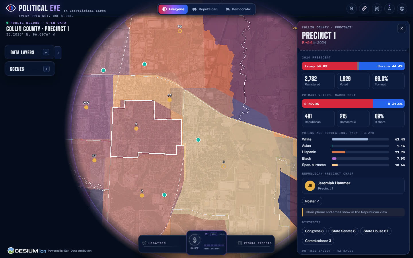
The precinct layers share one colour mode. 2024 shades by the presidential margin. Lean shades by the primary-ballot split. Turnout shades by the share of registered voters who voted. Hispanic, Asian, Black and White shade by share of voting-age population. Spanish surname shades by the share of registered voters with a Spanish surname. Statewide files carry 2024, lean, turnout and Spanish surname. Other modes leave statewide precincts on the 2024 ramp.
Live: early voting & results
- Group
- Votes
- Shows
- Every Texas county shaded by the share of its registered voters who have voted so far, from the Secretary of State's daily early-voting file (19–30 October 2026). On election night (3 November) counties take the leader's party as they report, with precincts reporting; the Precinct results chip paints the Dallas, Tarrant, Denton and Rockwall precincts by their own leader. A pulsing teal-and-gold ring marks a county edition with a live feed. The feed is checked every 60 seconds while the layer or a live card is open.
- Click
- Opens the county card, which leads with a LIVE section: the tally, the share of registered voters, in person and by mail, the change since the day before and a daily sparkline; on election night the top contests with bars and precincts reporting. Where nothing is live, the card shows the last results, when polls close and the official results page.
- Source
- Texas Secretary of State early-voting and election-night feeds; county elections offices (Scytl/Clarity for Dallas, Tarrant, Denton and Rockwall; Collin County's published CSV).
- Licence
- Public record. Attributed to the Texas Secretary of State and the county; unofficial until each canvass.
- Freshness
- Early voting: once a day from the state. Election night: every minute from 7 pm CT until the counties finish. Nothing is shown before polls close.
States 2024
- Group
- Votes
- Shows
- All 50 states and DC, shaded by the two-party Republican share of the 2024 presidential vote. State borders are always drawn. The fill shows above 3,400 km.
- Click
- Clicking a state opens the state card (result, votes cast, electoral votes, statewide officials, U.S. House delegation, county editions). It also loads that state's precincts and flies there.
- Source
- MIT Election Data + Science Lab, County Presidential Returns 2000–2024; seven states' counties from tonmcg/US_County_Level_Election_Results_08-24. Shapes: Census TIGER.
- Licence
- MEDSL: CC0. tonmcg: MIT. Census: public domain.
- Freshness
- 2024 general election, certified. Static snapshot; updated when a new release is loaded.
Counties 2024
- Group
- Votes
- Shows
- 3,144 counties on the same red–blue ramp. Counties show below 3,400 km. A county steps aside when its state's precincts or its county edition are on and loaded, and the camera is below 2,800 km.
- Click
- Opens the county card, or the county-edition card for Collin and Dallas.
- Source
- MEDSL County Presidential Returns; tonmcg; Census TIGER.
- Licence
- CC0 / MIT / public domain.
- Freshness
- 2024 general, certified. Static snapshot.
Statewide precincts 2024
- Group
- Votes
- Shows
- Every precinct (VTD) in the state under the camera, loaded when you come below 3,400 km. Texas has all 9,712. Colour modes: 2024 result, lean, turnout and Spanish surname. Precincts inside a county edition are left to that edition.
- Click
- Opens the statewide precinct card, with the source named on the card.
- Source
- Texas Legislative Council VTD election data; MEDSL precinct returns and VEST shapes for other states as they are added.
- Licence
- TLC: CC BY 4.0 (credit required). MEDSL: CC0. VEST: CC BY 4.0.
- Freshness
- 2024 general and March 2024 primary. Static snapshot.
County edition precincts
- Group
- Votes
- Shows
- Collin (273) and Dallas (791) precincts in full. Colour by 2024 result, lean, turnout, Hispanic, Asian, Black, White or Spanish surname. Outlines appear below 150 km and precinct numbers below 30 km.
- Click
- Opens the full precinct card: result, primary voters, voting-age demographics, chair, districts, races on this ballot and the nearest vote centres. Row chips open Races, Congress, Officers (Republican view) and the county card.
- Source
- Texas Legislative Council; U.S. Census 2020 PL 94-171; county elections offices.
- Licence
- TLC: CC BY 4.0. Census: public domain. County: public records.
- Freshness
- 2024 general, March 2024 primary, 2020 Census. Static snapshot.
Republican precinct chairs
- Group
- People
- Shows
- A pin at each precinct: a gold dot means the seat is filled, a gold ring means it's open. Shows below 320 km in the Everyone and Republican views. The Democratic view shows a locked chip.
- Click
- Opens the precinct card. Chair phone and email appear only in the Republican view.
- Source
- County Republican Party rosters, as published (the Collin website roster was last updated 2 December 2025).
- Licence
- Published by the party; used as published.
- Freshness
- As of the roster date on the card. Static snapshot.
Vote centres
- Group
- Places
- Shows
- Collin 90 and Dallas 443 vote centres. Shows below 900 km. LIST chips per county.
- Click
- Opens the vote-centre card: early voting, Election Day, hours, directions and the county source.
- Source
- County elections offices.
- Licence
- Public records.
- Freshness
- As published by each county for the election named on the card.
Events & clubs
- Group
- Places
- Shows
- Party events, coloured by kind, and clubs (pink ring), with EVENTS, CLUBS and LIST chips. Events show in the Everyone and Republican views; clubs only in the Republican view.
- Click
- Opens the event card (when, where, event page, directions) or the club card.
- Source
- County party calendars and club lists, as published.
- Licence
- Published by the party; used as published.
- Freshness
- As published. Past events drop off when the data is refreshed.
Districts
- Group
- Boundaries
- Shows
- Dashed outlines and labels for Congressional (on by default), State Senate, State House and county commissioner districts, with a chip for each kind.
- Click
- Click a label for the district card: the county's part of the 2024 result, the member of Congress, and races on the 2026 ballot.
- Source
- Census TIGER/Line; Texas Legislative Council; county GIS.
- Licence
- Public domain / CC BY 4.0 / public records.
- Freshness
- Current enacted districts. Static snapshot.
Radio & TV
- Group
- Media
- Shows
- 17,522 FM, AM and TV stations, loaded the first time you switch the layer on. FM, AM and TV chips.
- Click
- Opens the station card, with a link to the station's FCC political file (where campaigns' ad buys are filed).
- Source
- FCC licence data; FCC Online Public Inspection File.
- Licence
- Public domain (U.S. federal work).
- Freshness
- Static snapshot of the licence database.